
Delayed investigation into Kuranda Range alternatives begins
The State Government has now started its delayed investigation into improving access between Cairns and the Northern Tablelands, amid uncertainty over the future of the Kuranda Range.
The planning exercise comes as engineers also probe whether the Barron River Bridge on the Kennedy Highway at Kuranda needs replacing.
Tropic Now's own investigation has revealed the examination of alternate routes has been delayed by almost two years.
A media release dated May 2019 announced the start of a $1.25 million planning project.
“This project, which is expected to start in July, will strategically look at the roads between Cairns and the Northern Tablelands to identify and prioritise upgrades,” it reads.
“Then we’ll know what we need to focus on in our planning for improving sections of road between Cairns and the Northern Tablelands, including the Kuranda Range Road.”
When State Member for Barron River, Craig Crawford, reported in January the study was complete, Tropic Now requested a copy of the document under Right to Information, but was told by an officer it didn’t exist.
The Department of Transport and Main Roads has now confirmed the State Government has set aside $1.6-million for a ‘planning project to improve capacity and efficiency between Cairns and the Northern Tablelands.’
(Is there an echo? That sounds eerily familiar.)
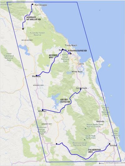
“The project considers all routes between Cairns and the Northern Tablelands, including Palmerston Highway, Gillies Range Road, Kennedy Highway, Mossman-Mt Molloy Road and other alternatives,” a spokesperson said.
“The project is expected to be complete mid this year.
“Key project outcomes and recommendations will be published.”
It’s understood maintenance tracks, including the Bridle Track, will also be looked at.
Federal Member for Kennedy, Bob Katter, is pushing hard for the Bridle Track to be built into a road, to cater for heavy vehicles and allow the Kuranda Range to be restricted to cars.
“We are negotiating with the Federal Government for a further $1.6-million to speed up the engineering plans and to get construction of the Bridle Track started,” he said.
WHAT IS THE BRIDLE TRACK?
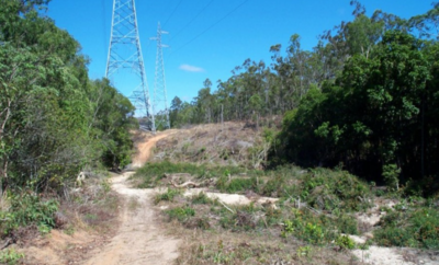
According to the Wet Tropics Management Authority (WTMA), Bridle Creek Road – or the Bridle Track – is a Wet Tropics management thoroughfare for a high voltage powerline.
It runs ten kilometres from the Bare Hill carpark at Davies Creek through rainforest until it meets Shoteel Creek Road, about two kilometres before Copperlode Dam.
WTMA says the road is currently suitable for mountain biking and hiking.
DEPARTMENT DEFENDS BRIDGE REPAIR DELAYS
Meantime, the Department of Transport and Main Roads has defended delays over repairs to the ageing Barron River Bridge, as revealed by Tropic Now following a Right to Information request.
A spokesperson said the delays were all part of the plan.
“More targeted engineering assessments of Barron River Bridge started after the routine bridge inspection report in 2015,” they said.
“The outcome was a restriction on excess mass vehicles and postponement of maintenance works recommended in the 2015 report.
“This is an example of the process working as it should – our response to the 2015 report led to more detailed assessments.
“Even if all the recommendations outlined in the 2015 report had been immediately completed, it would not have resolved current issues.
“The bridge is safe with the single-lane operation and 50.5-tonne load limit in place.”