
All eyes on the skies as tropical low intensifies
UPDATE 3pm 24/03/2017:
KEY FACTS
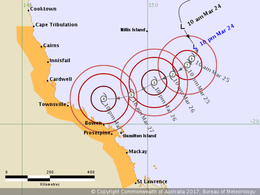
- BoM releases its first tracking map for Cyclone Debbie
- Coral Sea tropical low should develop into a tropical cyclone and move west towards the coast over the weekend
- Latest predictions show the system will cross between Cairns and Townsville
- People urged to follow updates on BoM website
People between Cape Tribulation and Proserpine are being urged to make preparations for the crossing of Cyclone Debbie on Monday, March 27.
Advice from the Bureau of Meteorology: "The tropical low has been showing signs of strengthening and has been moving towards the south.
"During Saturday the low is expected to develop into a tropical cyclone and adopt a track towards the west, bringing it towards the north Queensland coast. Conditions are expected to favour the continued intensification of the system as it approaches the coast over the weekend."
EARLIER 10am: BoM meteorologists this morning told TropicNow there was a “high chance” of an “at least Category Two, possibly Category Three” crossing the coast early on Monday.
Duty forecaster Andrew Mostyn said the low-pressure system – which will be named Debbie once it forms into a cyclone – would likely cross the coast somewhere between Cairns and Townsville.
Mr Mostyn said the system – currently 120km E/NE of Cairns – was between 12-24 hours away from developing into a Category One cyclone.
“At the moment it’s pretty much stationary, which means it’s consolidating and getting its gales going.
“Winds and rain will start this weekend in and around Cairns.
“As we head into the weekend, people should think about their plans and start preparing.
“For example, camping anywhere south of Cairns this weekend is a no-go.”
Mr Mostyn stressed that it was important for people to realise that, even if Debbie makes landfall further south, Cairns will still feel its effects.
“Even if it’s not a direct hit on Cairns, we’ll cop strong Westerly winds between Monday morning to Tuesday, especially on the Northern Beaches or anywhere with a mountain range behind it.
“People have to think about things like power loss and roads being cut, even if Debbie does go south.”
A tracking map will be online at the BoM site later this afternoon.
EARLIER: Atmospheric conditions are ripe for the formation of a cyclone in the Coral Sea, though forecasters say it’s too early to predict precisely where it may hit.
The Bureau of Meteorology is keeping close tabs on a low-pressure system southeast of Papua New Guinea, which could develop into a cyclone as it moves southwest towards the northern Queensland coast.
The bureau this afternoon upgraded the likelihood of a cyclone from moderate to high, meaning there is now an over 50 cent chance that the low will intensify into a cyclone on Sunday.
Duty forecaster Andrew Mostyn told TropicNow the developing low was “the kind of system you look at and say ‘Oh yeah!’”
“The model suggests a high probability of impact early next week, with significant rain and winds,” Mr Mostyn said.
“The environment is very favourable for it to develop into a tropical cyclone.
“Favourable conditions include things like having sea surface temperatures of over 26.5C, but more importantly, atmospheric conditions such as low vertical wind shear [a change of wind speed perpendicular to the wind's direction].
“And so far, we’ve got all of that.
“We expect it to sure-up within the next 48 hours.”
Mr Mostyn said it was impossible to forecast the future intensity of a potential cyclone before its formation, and urged people to follow the system’s developments on the BoM website.
“The bureau starts issuing warnings once a cyclone has actually developed and is about 48 hours away.
“Start checking the site for warnings sometime on Saturday or, at latest, early Sunday.”
He said it was equally impossible to predict exactly where the potential cyclone would hit, casting a wide net on coastal areas between Cape Tribulation to Mackay.
“However, the model suggests it’s most likely to impact somewhere between Cairns and Ayr.”
Mr Mostyn said it was the latest start to cyclone season in the Coral Sea since 1970 – when satellite images came into use – and possibly even before then.
This evening's development of a Category One cyclone off the coast of WA means that a Coral Sea cyclone, if it develops, will be named Debbie.
Mr Mostyn said earlier today said the Far North was “in a race” with Western Australia for naming rights to ‘Caleb’.
“Whoever gets it first, their cyclone will be called Caleb.
“Next on the list is Debbie.”
Cyclones are given names in alphabetical order, alternating between male and female monikers.